
Friday 22 February 2013
Friday 15 February 2013
National Trust Mission and Aims
Mission Statement
The National Trust was founded in 1895 to promote and look after places of historic beauty permanently for the benefit of the nation across England, Wales and Northern Island. Our core purpose is to look after special places for ever, for everyone.
We protect over 700 miles of coastline and in total we look after 617,500 acres (250,000 hectares) of countryside, moorland, beaches and coastline.
Amongst the historic properties in the Trust's care are 166 fine houses, 19 castles, 47 industrial monuments and mills, 49 churches and chapels, and 35 pubs and inns.
The millions of objects in the care of the National Trust reflect its diversity. Conservation staff and volunteers care for an astonishing range of structures and contents, from 26 sets of samurai armour, or 19 magnificent paintings by Turner, to the Oscar awarded to George Bernard Shaw, the national collection of lawnmowers, 57 meat strainers or a photograph album the size of a postage stamp.
The National Trust is an independent charity and receives no direct funding from the Government. Membership fees only cover just over a third of the total income we need in order to protect and provide access to the beautiful places in our care. We're a UK conservation charity, protecting historic places and green spaces, and opening them up for ever, for everyone.
National Trust aims to:
- Champion of volunteering. Our 55,000 volunteers contribute 3.1 million hours per year which equates to a notional value of more than £25 million.
- To look after places of historic interest or natural beauty permanently for the benefit of the nation across England, Wales and Northern Ireland
- A major employer,with 5,000 staff and training schemes for young people wishing to learn professional skills and embark on careers in horticulture and conservation.
- Europe’s leading conservation body, protecting through ownership, management and covenants 253,349 hectares (626,051 acres) of land of special importance and 707 miles (1,138 km) of coastline
- Responsible for saving and caring for thousands of historic buildings dating from the Middle Ages to modern times; ancient monuments, nature reserves, gardens, landscape parks, woodland and farmland.
Overview: National Trust
Established January 1895
Registered Charity Number 205846
5500 full time staff
61000 volunteers
Source: "the Big give" website - www.the biggive.org.uk
Friday 8 February 2013
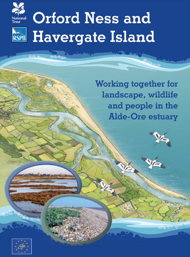
The Alde-Ore Estuary - Securing a Sustainable Future for Wildlife
Here is some interesting and relevant information found on the Alde-Ore LIFE website about the their project. It is definately worth taking a look at if you have the time as they play an important role in the management, evaluation and monitoring of the site http://www.lifealdeore.org/index.php?pid=1

Alde-Ore Future for Wildlife is a project helping to provide long term improvements to the management of National Trust Orford Ness and RSPB Havergate Island for birds and habitats of European importance.
With the support of the EU's LIFE+ programme, we are improving water management and reducing disturbance on this part of the Suffolk coast for the benefit of wildlife, habitats and landscape.
Orford Ness National Nature Reserve
An internationally important nature reserve, with a fascinating 20th-century military history.
Take a short boat trip to this wild and remote shingle spit, the largest in Europe. Follow trails through a stunning landscape and a history that will both delight and intrigue. Discover an internationally important nature reserve littered with debris and unusual, often forbidding, buildings from a sometimes disturbing past. Orford Ness is the best-preserved vegetated shingle site in the UK and holds 15% of the coastal vegetated shingle globally. Changing weather patterns have resulted in the marshes drying out and rectifying this is a main aim of the project.
The National Trust works to preserve and protect the coastline, countryside and buildings of England, Wales and Northern Ireland. For ever, for everyone
What is a LIFE+ Nature Project?
LIFE+ Nature is one of the European Union's main funding programmes for the environment and its conservation. LIFE+ Nature projects are subject to a rigorous application process, detailed evaluation and have to be supported by DEFRA in the UK. LIFE+ funds innovative, best practice projects that contribute to the implementation of the EU Birds and Habitats Directives on Natura 2000 Network sites.
This is the third time that LIFE funding has been awarded to the Alde-Ore area, underlining its international importance for wildlife and the pro-active work for wildlife conservation undertaken by the National Trust (NT) and the Royal Society for the Protection of Birds (RSPB).
What we have done on the lagoons and marshes?
A main aim of the project is to establish functional, efficient and sustainable systems of water management to maintain and improve the quality of the coastal lagoons and marshes in response to increasingly lower rainfall. A network of new ditches, lagoons and water controls have been installed, and we continue to monitor species, water quality and levels to ensure these sites are fantastic places for wildlife.
With the work now complete we are entering a period of experimentation and recording to find the best water levels and management regime.
Protection of nesting birds
Most of the bird species on Havergate Island and Orford Ness nest on the ground. This makes them, their eggs and young, very exposed to predation by several different predators from foxes, weasels and stoats to other birds like Gulls and Grey Heron. However, on Havergate Island a more significant problem is the large population of brown rats which cause many losses to breeding Avocets and Terns. After detailed monitoring and research, and the production of an action plan, work is starting on the removal of brown rats in order to protect the nesting birds.
Why is Orford Ness so unusual and why are some of its habitats so vulnerable?
Orford Ness is the largest vegetated shingle spit in Europe and the only one featuring a cuspate foreland. The shingle habitats at Orford Ness host unusual, and some unique, combinations of species, of plants, invertebrates and lichens. The shingle habitat is exceptionally vulnerable to disturbance as its ridge and furrow structure has been formed in a very particular pattern over a long period of time and so cannot be easily re-formed if damaged by human activities. The National Trust has a legal obligation to protect this valuable natural resource
Our aim is to engage with local communities and visitors to assist us in maintaining the fragile balance between offering access to these inspiring places and the essential conservation of the habitats and wildlife.
What surveys of the wildlife are we carrying out?
The National Trust and RSPB carry out regular wildlife surveys on these two sites. The breeding and wintering bird life has been counted for many years, and this will be continued, in even more detail, throughout the project, so we can evaluate how the birdlife is responding to the conservation work we are undertaking.
We shall also survey the plants and invertebrates of the coastal lagoon habitats during the project, to see how the water management improvements affect this wildlife. The completed survey results can be found here.


An Exerpt from the Alde-Ore Future for Wildlife
Ecological Monitoring Report: Baseline 2010-11
The NT and RSPB have been jointly awarded a LIFE+ Nature grant to further improve the
management of Orford Ness and Havergate Island for birds and habitats that are priorities for
conservation across Europe.
The main aim of the project is to establish a functional, efficient and sustainable system of ditches,
water controls, pumps and sluices to enable long-term water management and control of the coastal
lagoons at Havergate Island and the marshes and lagoons at Orford Ness. The project also includes
the monitoring and protection of vulnerable vegetated shingle habitat on Orford Ness.
Target bird species include Redshank, Avocet, Ruff and Sandwich Tern, Spoonbill, Golden Plover and
Little Tern, and priority habitats are coastal lagoons, vegetated shingle and strandline plant
communities.
Equipment has been purchased to enable or assist the monitoring actions. Monitoring locations have
been related to the concrete actions of the project, to ensure meaningful data are recorded and
comparisons can be made as the project progresses. Meetings have been held between the project
staff, including nature conservation advisors of both the RSPB and NT, to agree the types and
methods of monitoring required for input into the scientific reports. Follow-up meetings have been
arranged to review the survey data recorded.
Baseline surveys have been carried out since the start of the project in April 2010, on bird numbers,
water levels, water quality (salinity), and invertebrates. Vegetation surveys will be undertaken in
summer 2011 on Orford Ness marshes prior to the concrete conservation actions. Both sites also have
bird, vegetation and invertebrate data going back for several years. These datasets will enable the
effectiveness of the conservation actions to be judged, through comparison between areas, and with
previous years.
1.1 Aim
To be able to evaluate the impact of the new and improved management systems on
the wildlife of European significance present at Orford Ness and Havergate Island.
1.2
Actions
ACTION E.2: Scientific monitoring and surveys of the project sites
Regular scientific monitoring will be carried out across project sites to investigate the effectiveness of
the various habitat management works and engagement activities within the project.
Baseline ecological surveys will be carried out in each of the sub-sites of the project area, in the first 6
months of the project. A main focus will be to monitor the invertebrates (biomass, species) of the
coastal lagoons where work is planned to be carried out in the future, such as revised water level
management, island and berm creation.
Monthly systematic bird surveys will be carried out on each site and sub-site, to provide population
data for Annex 1 and other key bird species, with site-specific density estimates with meaningful
confidence limits, to be able to demonstrate statistically significant habitat associations among the
focal bird assemblage, and to be able to evaluate the impact of management works.
Expected results
On each of the sites we would expect to be able to determine, statistically, the effectiveness and
success of the habitat management works in terms of numbers of the targeted Annex 1 bird species,
and the lagoon invertebrates. In addition, there will be a reduced impact by mammalian predators, and
disturbance, to the targeted breeding bird species.
Survey Results
2.1 Bird surveys
Baseline surveys of all of the bird species, including the target bird species, were carried out on
Havergate Island and Orford Ness marshes in summer 2010 and winter 2010-11, prior to the proposed
concrete conservation actions being undertaken. In addition, both sites have detailed bird survey data
going back for several years.New Lagoons and Ditches

Photos


OTHER ARTICLES OF INTEREST FROM THEIR SITE AND BLOG..

Access to the southern end of the Spit
Nov
05
2012
Following a couple of letters in the East Anglian Daily Times, about the article that suggested the National Trust may wish to restrict access to Orford Ness, we'd like to clear up some of the misconceptions around how we look after this internationally important nature reserve.
Local people obviously have strong feelings about the way we look after this place, and have done so since we bought it from the MOD when they left over 20 years ago. We have already been in contact with many of them and would be very happy to discuss any concerns in the future but ultimately, we have a responsibility to the natural environment on this priceless site.
We have been carrying out surveys and monitoring both the natural history and access on Orford Ness since 1993 and are developing a significant record of the site. In addition, every six years or so the condition of each Site of Special Scientific Interest (SSSI) unit within the site is reviewed by Natural England and our last review resulted in a condition of 'unfavourable and declining' in the southern end of the spit. This has been caused largely by people accessing the site in an unauthorised way and compounded by not then sticking to the one footpath and spreading out along the spit. We are required by law to safeguard the area from further damage and we are obliged by our conservation principles to try to stop the decline.
Balancing the needs of access and conservation has always been a delicate matter but we are committed to ensuring that access continues. That's why we held a community forum and invited as many users and interested parties as we could find and get hold of to discuss the issues Orford Ness faces. We do not have the resources or the wish to police the area to stop further damage caused by people landing here.
We need solutions and we want to involve people in finding them. Some people tell us they have been visiting the spit for 50 years, along with hundreds of other people who land by boat and have picnics, swim and walk in the main during the summer months. Beach anglers take over and land on the river side of the spit to walk across to the seaward side from October to March. We are very happy for that to continue - but in a managed way and in a way where everyone takes responsibility for safeguarding the integrity of the site.
This year, apart from the substantial amounts of general rubbish left behind we had to remove three abandoned barbeques from this delicate area, and they could only have got there by boat. Would you leave a barbeque on Snowdon or Stonehenge? Why is this rarer habitat/landscape any less precious?
Unfortunately, although the area in question looks like any simple shingle beach it isn't. It is a world-class nature reserve with some of the most important vegetated shingle habitat with amongst the best preserved shingle ridges than anywhere else in Europe, if not the world. Every step off the designated routes destroys this complex habitat and wildlife community and it is highly unlikely to ever come back.
Orford Ness has to be a jewel in the crown of the Suffolk coast and we need to work together to protect it. We need everyone's help to keep it precious and special.
HERE IS A LINK TO SOME GOOD AERIAL PHOTOGRAPHY OF THE SITE, WORKS, INTERVENTIONS AND CHANGES, WITH ANNOTATIONS http://www.lifealdeore.org/index.php?pid=214&blogid=131
Thursday 7 February 2013
What is Orford Ness like?
What is the ‘built’ product - giving hard details and an idea of its appearance and atmosphere
National Trust
wild and remote shingle spit
stunning landscape
history that will both delight and intrigue.
internationally important nature reserve
often forbidding,
uncompromising about its past and in protecting its future.
15% of the world's reserve of coastal vegetated shingle
the best preserved shingle ridges in Europe
fragile
dangerous debris, including bombs, still remains.

Marsh

Creek

Shingle
Wiki
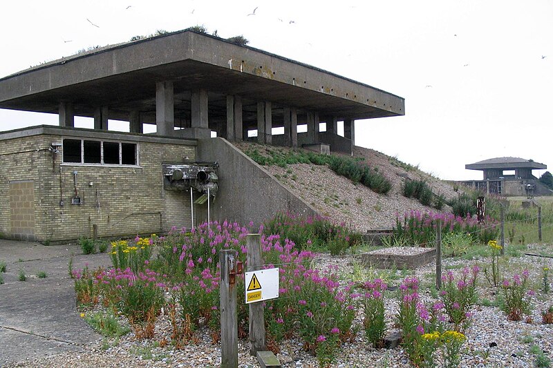
It is a place of strange contrasts. For the National Trust, its 'elemental nature' contrasts with the 'inherent dangers' of this place, a 'hostile and potentially dangerous site'. Military structures – the Bomb Ballistics Building, the Black Beacon, the 'pagodas' used for explosive design – have been converted into viewing spots. This is not a celebratory site, however; there is ambivalence and doubt here, with regard to what is being physically and ideologically conserved
approximately 10 miles (16 km) long
a total area of approximately 2,230 acres (900 ha).
Forty percent of this (890 acres) is shingle, 25 percent (556 acres) tidal rivers, mud flats, sand flats, and lagoons, eighteen percent (400 acres) grassland, and fifteen percent (330 acres) salt marsh.
The size and shape of the spit fluctuates over time
Buildings
Dan Pearson
The highlight of the weekend was a guided walk of the National Trust's Orford Ness. This internationally important nature reserve is the largest expanse of vegetated shingle habitat in Europe and, as such, supports a variety of flora and fauna. The Ness was occupied by the military for much of the 20th century and the shingle is littered with the remains of buildings and bomb test sites, which now take on a sculptural quality. The tension between the natural and the manmade, and the eerie atmosphere created by the oceans of pristine shingle is reminiscent of Dungeness, although here there are no houses and no inhabitants, apart from hares and sea birds.
Land being reclaimed by nature?
Galley
the ultimate place to get away from it all and clear your mind. It is the biggest shingle spit in Europe and was a top-secret military site from 1913 to the 1980s. Whether you re just soaking up the atmosphere of the wild open space, bird watching or imaging James Bond type scenarios it is a very special place.
EADT24
the public was kept away until the 1990s (a ruling that helped fan lots of wild speculation about actual nuclear weapons being tested there in the past).
“The combination of desolation, debris and weapons of mass destruction made it a threatening place for many of those who came to consider whether it might be a suitable acquisition for the National Trust
Orford Ness offered “monuments to the realities of twentieth-century history: unimaginable destruction, extermination as an industrial process, war directed as much at civilian populations as at opposing warriors
After 80 years off-limits, the site opened to the public in 1995 – the National Trust’s centenary year.
“The response to Orford Ness has been unusual,” suggests Merlin. “It is as though poets and painters have taken up where the Suffolk poet George Crabbe and Turner had left off.” (JMW Turner had in the summer of 1824 taken a boat from Aldeburgh down the Ore, filling page after page of a sketchbook with pencil drawings that inspired a series of watercolours.)
“One of the most thoughtful responses is in Christopher Woodward’s book In Ruins. He had been particularly struck by the Trust’s decision to allow the concrete pagodas to deteriorate gradually, without attempting to prevent or even slow down the rate of decay . . .”
Woodward wrote that “In a new and hopefully more peaceful century the ruins would crumble into extinction in exposure to the wind and waves, as if the earth was being purified by nature.”
National Trust
wild and remote shingle spit
stunning landscape
history that will both delight and intrigue.
internationally important nature reserve
often forbidding,
uncompromising about its past and in protecting its future.
15% of the world's reserve of coastal vegetated shingle
the best preserved shingle ridges in Europe
fragile
dangerous debris, including bombs, still remains.
Marsh
Creek
Shingle
Wiki
It is a place of strange contrasts. For the National Trust, its 'elemental nature' contrasts with the 'inherent dangers' of this place, a 'hostile and potentially dangerous site'. Military structures – the Bomb Ballistics Building, the Black Beacon, the 'pagodas' used for explosive design – have been converted into viewing spots. This is not a celebratory site, however; there is ambivalence and doubt here, with regard to what is being physically and ideologically conserved
approximately 10 miles (16 km) long
a total area of approximately 2,230 acres (900 ha).
Forty percent of this (890 acres) is shingle, 25 percent (556 acres) tidal rivers, mud flats, sand flats, and lagoons, eighteen percent (400 acres) grassland, and fifteen percent (330 acres) salt marsh.
The size and shape of the spit fluctuates over time

Buildings
Dan Pearson
The highlight of the weekend was a guided walk of the National Trust's Orford Ness. This internationally important nature reserve is the largest expanse of vegetated shingle habitat in Europe and, as such, supports a variety of flora and fauna. The Ness was occupied by the military for much of the 20th century and the shingle is littered with the remains of buildings and bomb test sites, which now take on a sculptural quality. The tension between the natural and the manmade, and the eerie atmosphere created by the oceans of pristine shingle is reminiscent of Dungeness, although here there are no houses and no inhabitants, apart from hares and sea birds.
Land being reclaimed by nature?
Galley
the ultimate place to get away from it all and clear your mind. It is the biggest shingle spit in Europe and was a top-secret military site from 1913 to the 1980s. Whether you re just soaking up the atmosphere of the wild open space, bird watching or imaging James Bond type scenarios it is a very special place.
EADT24
the public was kept away until the 1990s (a ruling that helped fan lots of wild speculation about actual nuclear weapons being tested there in the past).
“The combination of desolation, debris and weapons of mass destruction made it a threatening place for many of those who came to consider whether it might be a suitable acquisition for the National Trust
Orford Ness offered “monuments to the realities of twentieth-century history: unimaginable destruction, extermination as an industrial process, war directed as much at civilian populations as at opposing warriors
After 80 years off-limits, the site opened to the public in 1995 – the National Trust’s centenary year.
“The response to Orford Ness has been unusual,” suggests Merlin. “It is as though poets and painters have taken up where the Suffolk poet George Crabbe and Turner had left off.” (JMW Turner had in the summer of 1824 taken a boat from Aldeburgh down the Ore, filling page after page of a sketchbook with pencil drawings that inspired a series of watercolours.)
“One of the most thoughtful responses is in Christopher Woodward’s book In Ruins. He had been particularly struck by the Trust’s decision to allow the concrete pagodas to deteriorate gradually, without attempting to prevent or even slow down the rate of decay . . .”
Woodward wrote that “In a new and hopefully more peaceful century the ruins would crumble into extinction in exposure to the wind and waves, as if the earth was being purified by nature.”
Wednesday 6 February 2013
Rough Draft – Note form
Orford Ness Brief
Page 2 “A study of
the design team…..What worked? What
didn’t? What could have worked
better? What surprised you? What was unexpected?”
What worked?
·
Area conserved following departure of MOD
·
The
Orfordness/Shingle Street landform is unique within Britain in combining a shingle
spit with a cuspate foreland. The site
supports nationally-scarce plants, British Red Data Book invertebrates, and notable
assemblages of breeding and wintering wetland birds (see RAMSAR Info Sheet at
jncc.defra.gov.uk/pdf/RIS/UK11002.pdf).
·
Not sold for
residential/industrial or other development
·
Rare vegetated shingle habitat protected from
damage caused by human contact
§ Restricted
public access
§ Waymarked
paths
·
Legislative protection: National Nature Reserve,
part of Alde-ore Estuary SSSI (see Appendix A), Special Area of Conservation,
Special Protection Area, Ramsar Site, Area of Outstanding Natural Beauty and
Environmentally Sensitive area.
·
Area made safe for staff and visitors
o Demolished
unwanted structures and buildings
o Bomb
disposal
o Dangerous
areas quarantined and made ‘out of bounds’
o Visitors
only to use specified routes through the site
o Fenced
securely
·
Habitat conservation (see SSSI condition report
in Appendix A)
o Perennial vegetation increasing on the shingle
o Increasing wintering and breeding birds on the grassland
o Saltmarsh generally in good condition
What are some of
the issues?
·
Public access too restricted?
·
Conflict between a historical site and a nature reserve?
·
Why spend so much effort and money trying to hold back nature – sea level rising,
coastal erosion (squeeze) etc?
·
Strandline deficient in flora –
evidence of trampling. The site now has an access warden and
research/action being undertaken (part of their EU LIFE+ Nature project).
·
Shingle deficient in annual plants – in
common with much of the Suffolk coast
·
Substantial decline in the lesser
black-backed gull population on the ness.
Possible reasons: predation by
foxes (key), habitat change, increased use of roof top nest sites in industrial
and urban areas, disturbance of nest sites by recreational boaters, walkers and
fisherman, reduction in available food through decrease in pig production and
changes in landfill practice, and potential effect of the rapid increase in
Chinese Water Deer.
·
A 0.42ha
loss in extent of saltmarsh between 1999/00 to 2006/07 in unit 23, however, the
Alde-Ore Estuary as a whole has gained 11.13ha in extent of saltmarsh in the same
period. Some of the reduction was as a result of managed re-alignment to offset
deterioration caused by coastal squeeze and this should improve the condition of the littoral sediment.
What surprised us?
?
?
What was unexpected?
?
?
Appendix A
Alde-ore Estuary SSSI
http://www.sssi.naturalengland.org.uk/Special/sssi/unitlist.cfm?sssi_id=1003208

Operations likely to damage the
special interest
Site name: Alde-Ore Estuary,
Suffolk
OLD1003208
Ref.
No. Type of Operation
1
Cultivation, including ploughing, rotovating, harrowing, and re-seeding.
2 The
introduction of grazing and changes in the grazing regime (including type of
stock or
intensity or seasonal pattern of grazing and cessation of grazing).
3 The
introduction of stock feeding and changes in stock feeding practice, including
changes in
the number of animals stocked.
4 The
introduction of mowing and changes in the mowing or cutting regime
(including
hay making to silage and cessation).
5
Application of manure, fertilisers and lime.
6
Application of pesticides, including herbicides (weedkillers).
7 Dumping,
spreading or discharge of any materials.
8 Burning.
9 The
release into the site of any wild, feral or domestic animal*, plant or seed.
10 The
killing or removal of any wild animal*, excluding pest control and game
species.
11 The
destruction, displacement, removal or cutting of any plant or plant remains,
including
tree, shrub, herb, hedge, dead or decaying wood, moss, lichen, fungus,
lead-mould
or turf etc.
12 The
introduction of tree and/or woodland management and changes in tree and/or
woodland
management+.
13a
Drainage (including the use of mole, tile, tunnel or other artificial drains).
13b
Modification of the structure of water courses (eg rivers, streams, springs,
ditches,
dykes,
drains), including their banks and beds, as by re-alignment, regrading and
dredging.
13c
Management of aquatic and bank vegetation for drainage purposes (see also 11).
14 The
changing of water levels and tables and water utilisation (including
irrigation,
storage and
abstraction from existing water bodies and through boreholes).
15
Infilling of ditches, dykes, drains, ponds, pools, marshes or pits.
16a The
introduction of freshwater fishery production and/or management excluding
sporting
fishing and angling.
16b Changes
in coastal fishing practice or fisheries management and seafood or marine
life
collection and culture including the use of traps or fish cages.
17
Reclamation of land from sea, estuary or marsh.
18 Bait
digging in intertidal areas.
19 Erection
of sea defences or coast protection works, including cliff or landslip
drainage or
stabilisation measures.
20 Extraction
of minerals, including peat, shingle, sand and gravel, topsoil, subsoil, and
spoil.
21
Construction, removal or destruction of roads, buildings, tracks, walls,
fences,
hardstands,
banks, ditches or other earthworks, or the laying, maintenance or
removal of
pipelines and cables, above or below ground.
22 Storage
of materials.
23 Erection
of permanent or temporary structures, or the undertaking of engineering
works,
including drilling.
24
Modification of natural or man-made features (including battering, buttressing
or
grading
cliff-faces, infilling of pits and quarries, or regrading shingle ridges).
26 Use of
vehicles or craft likely to damage or disturb features of interest including
shingle
ridges and vegetation, or disturb wildlife.
27
Recreational or other activities likely to damage features of interest
including
shingle
ridges and vegetation, or disturb wildlife.
28 Changes
in game and waterfowl management and hunting practice.
* “animal”
includes any mammal, reptile, amphibian, bird, fish or invertebrate.
+ including
afforestation, planting, clear and selective felling, thinning, coppicing,
modification
of the stand or underwood, changes in species composition, cessation of
management.
SSSI condition summary
Compiled:
01 Jan 2013
SSSI name:
Alde-Ore Estuary
|
% Area
meeting PSA target
|
% Area
favourable
|
% Area
unfavourable recovering
|
% Area
unfavourable no change
|
% Area
unfavourable declining
|
% Area
destroyed / part destroyed
|
|
88.51%
|
62.67%
|
25.84%
|
0.64%
|
10.85%
|
0.00%
|

|
|
|
Unit area (ha)
|
Latest assessment date
|
Assessment description
|
Condition assessment comment
|
|
|
Supralittoral sediment
|
17
|
29.91
|
06 Aug 2009
|
Favourable
|
A band of 25m of shingle with
little/no signs of annuals but some perennials. Behind this section, the
shingle is a mass of sea pea and grasses. Annual species – field notes
indicate little to no sign of annuals. However transect data has spear-leaved
orache in ten out of ten quadrats (abundant). No other species were recorded
– Fail. Good band of perennial vegetation with large amounts of sea pea.
Perennial vegetation includes three species which are Abundant, one Frequent
and two rare species. – Pass There is a brief mention of trampling on this
unit but the perennial vegetation passes the CSM minimum target. Annual
vegetation fails the CSM but this appears to be the case all along the
Suffolk Coast and I think there may be a case for the targets to be adjusted.
This Unit and adjacent shingle units need to be re-assessed in view of what
may be considered an acceptable degree of disturbance within different units.
|
|
|
Neutral grassland - lowland
|
18
|
99.70
|
27 Oct 2009
|
Favourable
|
This unit is part of the site fabric
that supports some of the breeding and over wintering birds the site was
notified for. Bird numbers are increasing under the present management.
Southern section Areas of open water with patches of saltmarsh, mud and taller
grasses (Elymus pyc/rep, Dactylus glom and Arrhenatherum with Agrostis sto.
under). Northern section This is predominantly coarse grasses with little or
no areas of open water or short grassland areas.
|
|
|
Littoral sediment
|
19
|
31.58
|
21 May 2010
|
Favourable
|
Northern shore - follows Stony Ditch
along sea wall with well established creeks and salt pans present within the
saltmarsh. Low- mid saltmarsh species include common saltmarsh grass, sea
purslane, sea blite and common sea lavender with some greater sea spurrey and
sea milkwort on higher areas. Sea couch and Sea wormwood present on sea wall.
Shingle ridge behind sea wall in NW of unit. Southern Shore – there is an
extensive area of low-mid saltmarsh with approximately 10% of the area consisting
creeks and salt pans. The saltmarsh is backed by vegetated shingle/lichen
heath. No evidence of grazing, trampling or vehicle damage. No distinct
transition between saltmarsh zones on northern shore. On southern shore there
is a transition from low-mid saltmarsh to vegetated shingle/lichen heath. The
transition zone is about 5 metres wide. A number of waders and wildfowl
including 6 redshank, 16 brent geese, 1 curlew and 2 little egret. Spartina
maritima occational to locally frequent over marsh. In order to investigate
coastal squeeze a study by IECS (2010) was commissioned and this showed a
0.21ha loss in extent of saltmarsh between 1999/00 to 2006/07 in this unit.
|
|
|
|
|
|
|
|
However, the study also showed that
the Alde-Ore Estuary as a whole has gained 11.13ha in extent of saltmarsh in
the same period. Some of this area was a result of managed re-alignment . As
the driver for managed re-alignment here has not been to offset the effects
of a plan or project but to offset deterioration caused by coastal squeeze
these gains should contribute to the condition of the littoral sediment units
within the site and help to push them into favourable condition.
|
|
|
Supralittoral sediment
|
20
|
81.61
|
10 Nov 2010
|
Unfavourable recovering
|
The species composition for the
stable shingle did not meet the targets set, despite good species diversity
over much of the unit. The strandline only had one target species with other
target species not being known/expected at this location (along with much of
Suffolk Coast). In addition the coast is actively eroding (natural coastal
process) with implications for strandline flora. Accordingly, the strandline
target should be adjusted and the strandline found to be in favourable
condition. Trampling was noted as significant during the field assessment,
however access is limited to specific areas due to presence of unexploded
ordnance and access areas have not changed since NT took over the site. There
is some unauthorised access to areas of the Unit (and beyond) and the site
now has an access warden and research/action being undertaken (part of their
EU LIFE+ Nature project) (as a remedy to trampling of shingle). Given that
the trampling issue is being dealt with and the generally outstanding shingle
flora present the site should be assessed as unfavourable recovering, however
the Unit needs to be carefully monitored with regard to reduction in
unauthorised trampling.
|
|
|
Supralittoral sediment
|
21
|
112.43
|
28 May 2012
|
Favourable
|
The majority of LBBG within the
Alde-Ore Estuary SSSI/SPA have until recently bred on breed on Havergate
Island (Unit 25) and Orfordness Lantern Marshes (Unit 16) the Pagoda roofs
(Unit 21) and on the southern end of the Ness (Unit 27). In recent years they
have also bred on the roof of the Cobra Mist building. There has been a major
decrease in LBBG breeding numbers overall on the SSSI since a peak in 2000,
notably on Orfordness. The 5YM for LBBG (Orfordness and Havergate), between
2002-2006 was 5877, just 41% of the population target. Between 2006 and 2010
the 5YM was 2471 (Orfordness and Havergate), was just 17.6%. The feature is
clearly in unfavourable declining condition as the SSSI/SPA population is not
being maintained within acceptable limits; that is above 75% of that at
designation/ loss of 25% or more is unacceptable. However, Havergate Island
is showing an increase in LBBG numbers and an accordingly positive population
trend. It has been less important for LBBG in the past with numbers gradually
increasing since the early 2000’s, possibly as birds moved off Orfordness.
Unit 25 should not be considered in unfavourable condition for LBBG.
|
|
|
|
|
|
|
|
The Pagoda roof tops (Unit 21) have
seen a stable breeding population of LBBG and should be considered favourable
accordingly. Reasons for the collapse of the gull population on Orfordness
have not been concluded but are thought to be due to: Predation by foxes
(key), habitat change, increased use of roof top nest sites in industrial and
urban areas, disturbance of nest sites by recreational boaters, walkers and
fisherman, reduction in available food through decrease in pig production and
changes in landfill practice, and potential effect of the rapid increase in
Chinese Water Deer.
|
|
|
Neutral grassland - lowland
|
22
|
86.50
|
27 Oct 2009
|
Favourable
|
This unit is part of the site fabric
that supports some of the breeding and over wintering birds the site was
notified for. Bird numbers are increasing under the present management. The
unit consists ditches with high water levels, areas of tall coarse grass,
areas of short grass and brackish pools.
|
|
|
Littoral sediment
|
23
|
35.03
|
21 May 2010
|
Favourable
|
Southern Shore – there is an
extensive area of low-mid saltmarsh with approximately 10% of the area
consisting creeks and salt pans. The saltmarsh is backed by vegetated
shingle/lichen heath. Transition of low to mid saltmarsh to vegetated
shingle/lichen heath. The transition zone is about 5 metres wide. In SW of
unit low to mid saltmarsh with frequent creeks and saltpans with large deep
creeks extending to base of sea wall in many places. Common saltmarsh grass,
sea purslane and glasswort dominant. Sea couch and sea wormwood present on
sea wall. Northern Shore – Mid marsh with areas of higher ground dominated by
sea couch and backed by sea wall. Creeks and saltpans represent 10-15% of
marsh area. Shingle beach forming in place at the front edge of the marsh and
some patches of shingle dumped on the marsh (not significant). No evidence of
recent engineering work but one old straightened creek at western end of unit
adjacent to northern shore. Spartina maritima occational to locally frequent
over marsh.
|
|
|
|
|
|
|
|
In order to investigate coastal squeeze a
study by IECS (2010) was commissioned and this showed a 0.42ha loss in extent
of saltmarsh between 1999/00 to 2006/07 in this unit. However, the study also
showed that the Alde-Ore Estuary as a whole has gained 11.13ha in extent of
saltmarsh in the same period. Some of this area was a result of managed
re-alignment . As the driver for managed re-alignment here has not been to
offset the effects of a plan or project but to offset deterioration caused by
coastal squeeze these gains should contribute to the condition of the
littoral sediment units within the site and help to push them into favourable
condition.
|
|
|
Littoral sediment
|
24
|
117.32
|
21 May 2010
|
Favourable
|
The salt marsh is present in small
sections along the western bank of the river, and is backed by a sea defence
wall supporting the coastal footpath. Along the majority of the unit, the
marsh is backed by grazing marsh with some arable farming. The unit includes
the town of Orford which sits on the river, and here there is a small marina,
with the sea wall continuing. Very little marsh vegetation is present to the
west of Orford, here the tidal muds extend up to the sea wall and offer
little chance for marsh development. The sea wall has resulted in significant
coastal squeeze, with evidence of erosion along seaward edge, and is
therefore dominated by mid-level communities which shelve directly into the
muds of the river bed. Lower level communities are largely absent. Creeks and
salt pans are frequent in places, with large, deep creeks extending up to the
base of the sea wall. Disturbance by cattle is frequent, with grazing of
vegetation and heavy poaching observed along most of the unit. This has
resulted in more open habitats close to the sea wall, where standing water
and bare ground are more frequent. Public access is limited to the footpath,
which results in little impact on the marsh as the footpath follows the sea
wall and access onto the marsh is infrequent. No obvious transition between
different saltmarsh zones.
|
Views About Management
A statement of English Nature’s views
about the management of Alde-Ore Estuary Site of Special Scientific Interest
(SSSI).
This statement represents English Nature’s
views about the management of the SSSI for nature conservation. This statement
sets out, in principle, our views on how the site’s special conservation
interest can be conserved and enhanced. English Nature has a duty to notify the
owners and occupiers of the SSSI of its views about the management of the land.
Not all of the management principles will be equally
appropriate to all parts of the SSSI. Also, there may be other management
activities, additional to our current views, which can be beneficial to the
conservation and enhancement of the features of interest.
The management views set out below do not constitute
consent for any operation. English Nature’s written consent is still required
before carrying out any operation likely to damage the features of special
interest (see your SSSI notification papers for a list of these operations).
English Nature welcomes consultation with owners, occupiers and users of the
SSSI to ensure that the management of this site conserves and enhances the
features of interest, and to ensure that all necessary prior consents are
obtained.
Management Principles
Estuaries
Estuaries are relatively natural habitats which
generally require little direct intervention to maintain them. Their proper
management requires an understanding of the inputs and processes, both natural
and otherwise, which affect them, and needs to be responsive to these factors.
The Alde-Ore Estuary needs to be considered as a
single functional unit that will respond to a variety of influences such as sea
level rise, coastal squeeze and changing sediment regimes. The location and
extent of habitats such as saltmarshes and mudflats depends upon the extent to
which the estuary is constrained from responding to these influences. In the
absence of constraints such as flood banks and hard defences, the estuary would
adjust to sea level rise by inland translocation of intertidal habitats. Where
constraints occur, space to accommodate greater volumes of water is compressed
and the extent and quality of intertidal habitats declines.
The maintenance of high quality estuarine
habitats such as saltmarshes and mudflats is essential if the associated plant
and animal communities are to be maintained. In addition there are a variety of
wetland habitats on the coastal flood plain that contribute to the overall
importance of the Alde-Ore Estuary, including coastal
Alde-Ore
Estuary Views About Management, Countryside and Rights of Way Act 2000,
Schedule 11(6) Version date: 02/06/05 Page 1 of 6 Alde-Ore Estuary Views About
Management, Countryside and Rights of Way Act 2000, Schedule 11(6) Version
date: 02/06/05 Page 2 of 6
grazing marshes,
brackish and freshwater pools and ditches. This combination of wetland and
intertidal interest features, which may be dynamic over time, provides the
feeding, roosting and nesting sites for the large numbers of breeding,
wintering and passage wildfowl and waders.
Coastal saltmarsh
Saltmarshes form the upper vegetated
portions of intertidal mudflats in sheltered coastal locations, such as
estuaries, lagoons and beach plains. There is typically a zonation of
vegetation, from plants adapted to regular immersion by the tides (halophytes),
through to more widespread plant species in the areas less frequently covered
by the sea. The halophyte plant species are confined to this type of habitat,
and areas of structurally diverse vegetation provide good invertebrate habitat.
Saltmarshes are also important nursery sites for several fish species, and
important refuge, feeding and breeding grounds for wading birds and wildfowl.
Where saltmarshes require management
this has traditionally been achieved by grazing, and previously used regimes
should be continued. Grazing provides a variety of different habitats,
particularly for wintering bird species, and if grazing were to cease there may
be a loss of botanical diversity. The precise timing and intensity will vary
according to local conditions and requirements, for example the type or
availability of stock, or the need to avoid trampling ground nesting birds.
However on many sites, the aim of will be to create a short turf that can be
attractive to over-wintering wildfowl, with a reduction in stock density in the
early summer for the benefit of ground-nesting birds. Indeed, careful reduction
of grazing can increase the number of breeding birds, without significantly
altering the plant species composition. Care should be taken not to overgraze
the site, as this may reduce the diversity of animal and plant species that the
saltmarsh is able to support, as well as potentially impact the sediments
supporting the saltmarsh.
Not all saltmarsh habitats require
active management to retain their conservation interest. Where there has not
been a history of grazing, the saltmarsh will be able to maintain itself and
grazing-sensitive species are likely to be present, therefore grazing should
not be introduced.
There are a number of factors that
are contributing to saltmarsh change that management may need to take into
consideration. These include coastal erosion as a result of coastal flood-defence
works, rising sea-levels, variations in sediment deposition, and land claim for
development.
Littoral sediments (mud and sand
flats)
Intertidal mud and sand flats include
a range of generally muddy or sandy low-gradient shores that are exposed to air
during low tide and submerged during the higher tides. High energy shores, such
as those on open coasts, are generally sandy in nature whilst more sheltered,
low energy flats are muddier. They support a wide variety of marine
invertebrates that represent an important food source for many fish and bird
species. Alde-Ore
Estuary Views About Management, Countryside and Rights of Way Act 2000,
Schedule 11(6) Version date: 02/06/05 Page 3 of 6
Good
water quality and sediment quality should be maintained, and the sediment
budget within the estuarine or coastal system should not restricted by
anthropogenic influences.
The birds that use mud and sandflats
for feeding and roosting are vulnerable to disturbance from human activities,
for example, bait digging, dog walking and wildfowling. These activities can
lead to reduced time spent feeding, or individuals being restricted to areas
with a poor food supply. Disturbance should therefore be minimised, especially
at times when bird populations may be stressed, such as during severe winter
weather.
The location and extent of mud or
sandflats is dependent on the extent to which the estuary or coast where they
occur is constrained from responding to sea level rise and changing sediment
regimes. Management needs to create space to enable landward roll-back to take
place in response to sea-level rise, and should also allow the system to be
dynamic and retain the flexibility to respond to associated changes such as the
movement of physical features within the system, e.g. migrating subtidal
sandbanks.
Orfordness and Shingle Street
geomorphology
Geomorphological sites where the
natural processes that produced the important scientific features are still
occurring are referred to as ‘active process sites’. The primary management
principle is to avoid interfering with these natural processes and the features
they produce.
Any development or activity that
restricts natural processes is likely to damage the interest features of the
site. Direct damage can be caused by activities such as the construction of
structures and defences, or the removal of material such as sand and gravel. In
some instances, sites are likely to be damaged by tree planting which can
restrict natural processes by stabilising the soil. Changes in drainage
patterns can also damage active process sites.
Developments do not necessarily have
to take place within the boundary of a site to cause damage. Natural systems
can be complex. For example, development in one area can disrupt active
processes in a site many miles away by altering rates of erosion. As processes
within a site can be affected by developments beyond the site boundary, it is
important to take a broad and integrated approach to the management of active
process sites.
In general, active management of
these sites is often only necessary if human activities have affected the
natural processes. For example, management may involve removal of man-made
barriers which restrict the natural movement of geological features, clearance
of rubbish or planted trees.
Collecting of geological specimens
may be acceptable if undertaken in a responsible manner. However, there are
some sites where the geological interest is very finite in nature and
over-collecting can result in damage or destruction of the interest. Collecting
of specimens requires very careful management to ensure that the geological
resource is conserved. Where there is any doubt, a precautionary approach
should be adopted before removing or allowing any material to be removed. Alde-Ore Estuary Views About
Management, Countryside and Rights of Way Act 2000, Schedule 11(6) Version
date: 02/06/05 Page 4 of 6
Vegetated
shingle
Shingle is defined as sediment with
particle sizes from 2-200mm. Shingle beaches form where sediment is first
deposited on the shore by wave action. These deposits can then build up into
more stable spits, bars or forelands. The types of vegetation that occur on
shingle depend on the stability and structure of the shingle itself, but all
must be able to cope with the unique physical and hydrological conditions
typical of this habitat. This results in some communities being unique to
shingle; including unusual moss- and lichen-rich communities that are of great
conservation value. Shingle structures also provide important habitats for
invertebrates and breeding birds.
A key management requirement is to
avoid or minimise surface disturbance, especially in the more open communities.
Many of the vegetation types and species associated with shingle are fragile
and vulnerable to damage from trampling. This breaks up the fine humus that
develops in the upper layers of the shingle that is vital for the plants to
survive. Where recreational pressures are significant enough to result in the
loss of vegetation cover, or prevent its recovery, it may be necessary to take
steps to manage access. Disturbance of areas important for breeding birds
should be minimised during the breeding season.
Where there is more closed vegetation
cover, light grazing, by rabbits for example, may be all that is needed to
prevent scrub encroachment on areas of grassland and heath. However, if there
is a tradition of sheep grazing; it may be beneficial to continue this practice
at a low intensity. In some cases grazing is not necessary, because of the low rates
of plant growth on shingle structures, and can even be damaging, due to the
fragility of shingle habitats. The introduction of grazing where it has not
been traditionally practiced would not be beneficial.
Coastal lagoons
Coastal lagoons such as those on
Orfordness and at Shingle Street are saline water bodies separated from the sea
by a barrier (e.g. sand, shingle or rock sill). A small number are separated by
tidal narrows which restrict the flow of water into and out of the lagoon. This
separation from the sea makes them unique among coastal habitats and means that
saline lagoons are either tideless, or where inlets occur, the tide has only a
restricted effect on the lagoon. They retain part of their water-body at low
tide, and this water may be either saline or brackish. They often support
unusual assemblages of marine, estuarine and aquatic plants and animals,
including lagoonal specialist species.
Any management needs to be carefully
tailored to the needs of each individual lagoon and should be based on an
understanding of the natural features of importance and the external factors
affecting the lagoon. Indeed, where a lagoon is in a good and stable condition,
active management is unlikely to be necessary. Maintaining salinity and water
depths can be a key management priority, particularly where some lagoons become
increasingly separated from the sea as a result of natural coastal processes -
the balance between freshwater (e.g. from rainfall, streams or artificial
outputs) and saline (i.e. sea water) inputs may change as a result. It may be
necessary to actively manage freshwater and seawater input to favour certain
species or communities. Whilst freshwater input is not essential to the
conservation of lagoons, some connectivity with seawater is. Alde-Ore Estuary Views About
Management, Countryside and Rights of Way Act 2000, Schedule 11(6) Version
date: 02/06/05 Page 5 of 6
The
water depth is also critical to many of the lagoonal specialist species with a
depth between 0.5 and 1m being desirable. Some deeper water refuges are also
beneficial. Siltation from surrounding land run-off may need to be addressed.
Water quality, and any direct and/or
diffuse inputs from the surrounding land, can have a profound effect upon the
productivity of lagoons and well-being of specialist species. Saline lagoons
can show extreme reactions to a build up of some types of nutrients and therefore
it may be necessary to actively manage inputs, especially where in close
proximity to farmland.
In some cases, it may be desirable to
allow vegetation to encroach into the lagoon to increase the diversity of
habitats present, particularly for some breeding and migratory bird species.
However vegetation should not be allowed to encroach to such an extent that it
significantly reduces the areas of open water and shallow water, thus reducing
the variety of habitats available to specialist species within the lagoon
itself.
Islands in saline lagoons can be
important for breeding birds and some management of the vegetation on these
islands may be necessary to provide the best conditions for breeding birds. Two
typical methods of vegetation control include flooding and hand clearance.
Coastal Cliffs and Foreshore
(Gedgrave Cliff)
Coastal geological sites form a very
important part of England's geological resource for two reasons. Firstly, in
many areas the only natural rock exposures are on the coast. Secondly, coastal
cliffs often provide much better exposure of geological features than
comparable inland sites.
The key management principle for
coastal geological sites such as Gedgrave Cliff is to maintain exposure of the
geological interest by allowing natural processes to proceed freely.
Inappropriate construction of coastal defences can completely conceal rock
exposures and result in the effective loss of the geological interest. In
addition, any development which prevents or slows natural erosion can have a damaging
effect. Erosion is necessary to maintain fresh geological outcrops. Reducing
the rate of erosion usually results in rock exposures becoming obscured by
vegetation and rock debris.
Coastal processes are complex and no
section of coastline exists in isolation. This means that coastal protection
has indirect effects on other parts of the coast. Developments do not
necessarily have to take place within the boundary of a site to cause damage.
For example, cliff protection in one area may starve other beaches of sediment,
accelerating cliff retreat elsewhere. As processes within a site can be
affected by developments beyond the site boundary, it is important to take a
broad and integrated approach to coastal management. This can provide
significant benefits to the conservation of coastal geological sites.
Active management of coastal
geological sites is often only necessary when human activity has interfered
with natural rates of erosion. Clearance of vegetation or rock debris may be
necessary to re-expose geological features where they have become obscured. Alde-Ore Estuary Views About
Management, Countryside and Rights of Way Act 2000, Schedule 11(6) Version
date: 02/06/05 Page 6 of 6
Collecting
of geological specimens may be acceptable if undertaken in a responsible
manner. However, there are some sites where the geological interest is very
finite in nature and over-collecting can result in damage or destruction of the
interest. Collecting of specimens requires very careful management to ensure
that the geological resource is conserved.
Certain activities can cause direct
damage to geological sites located on the foreshore and management should aim
to avoid or, if necessary, minimise any harmful effects. Such activities
include dredging, construction of pipes, heavy machinery crossing the
geological features and, in some instances, the introduction of large
quantities of beach feed material.
All habitats
The habitats within this site are highly sensitive to
inorganic fertilisers and pesticides, applications of which should be avoided
both within the site itself and in adjacent surrounding areas. Herbicides may
be useful in targeting certain invasive species, but should be used with
extreme care. Access to this site, and any recreational activities within, may
also need to be controlled. SSSI
condition summary
Compiled: 01 Jan 2013
Subscribe to:
Posts (Atom)